Mynd:Wpdms aq block 1614.jpg
Stærð þessarar forskoðunar: 429 × 599 mynddílar Aðrar upplausnir: 172 × 240 mynddílar | 344 × 480 mynddílar | 550 × 768 mynddílar | 733 × 1.024 mynddílar | 1.466 × 2.048 mynddílar | 5.744 × 8.021 mynddílar.
Upphafleg skrá (5.744 × 8.021 mynddílar, skráarstærð: 7,61 MB, MIME-gerð: image/jpeg)
Lýsing
| Description |
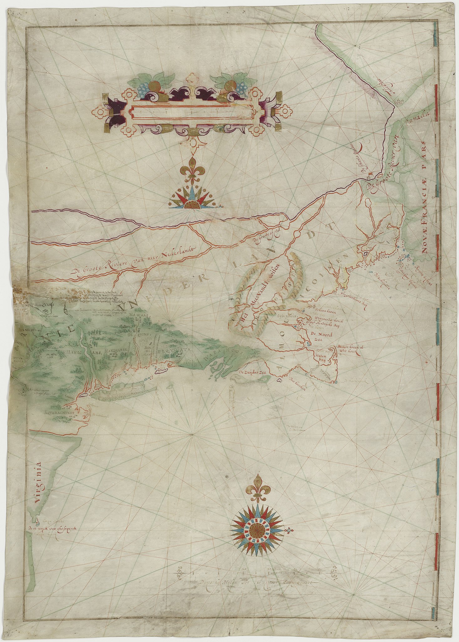
English: Map made by w:Adriaen Block of his 1614 expedition to North America. It is the first map to show Long Island as an island. It is also the first appearance of the term New Netherland to describe the colony (17th century drawing). |
|||||||||
| Dagsetning | ||||||||||
| Uppruni | digitalized by the Dutch National Archive (perm link) | |||||||||
| Skapari | ||||||||||
| Geotemporal data | ||||||||||
| Bounding box |
|
|||||||||
| Georeferencing | ||||||||||
| Aðrar útgáfur | File:The figurative map of Adriaen Block (NYPL Hades-118535-54659).tif | |||||||||
Leyfisupplýsingar:
|
This is a faithful photographic reproduction of a two-dimensional, public domain work of art. The work of art itself is in the public domain for the following reason:
The official position taken by the Wikimedia Foundation is that "faithful reproductions of two-dimensional public domain works of art are public domain".
This photographic reproduction is therefore also considered to be in the public domain in the United States. In other jurisdictions, re-use of this content may be restricted; see Reuse of PD-Art photographs for details. | ||||
Breytingaskrá skjals
Smelltu á dagsetningu eða tímasetningu til að sjá hvernig hún leit þá út.
| Dagsetning/Tími | Smámynd | Víddir | Notandi | Athugasemd | |
|---|---|---|---|---|---|
| núverandi | 18. maí 2021 kl. 18:41 | | 5.744 × 8.021 (7,61 MB) | Ciell | Larger digitalisation from the Dutch National Archive |
| 17. febrúar 2012 kl. 17:15 |  | 456 × 640 (104 KB) | Gladiool | Better quality version of the same image. Found at [http://www.stonybrook.edu/libmap/coordinates/seriesa/no5/block.jpg]. | |
| 28. september 2005 kl. 21:00 |  | 350 × 499 (31 KB) | Longbow4u | *Description:Map made by w:Adriaen Block of his 1614 expedition to North America. It is the first map to show Long Island as an island. It is also the first appearance of the term New Netherland to describe the colony (17th century drawing). *Sour |
Skráartenglar
Eftirfarandi síða notar þessa skrá:
Altæk notkun skráar
Eftirfarandi wikar nota einnig þessa skrá:
- Notkun á af.wiki.x.io
- Notkun á azb.wiki.x.io
- Notkun á be.wiki.x.io
- Notkun á ca.wiki.x.io
- Notkun á de.wiki.x.io
- Notkun á en.wiki.x.io
- Notkun á es.wiki.x.io
- Notkun á et.wiki.x.io
- Notkun á fa.wiki.x.io
- Notkun á fr.wiki.x.io
- Notkun á fy.wiki.x.io
- Notkun á hr.wiki.x.io
- Notkun á it.wiki.x.io
- Notkun á ja.wiki.x.io
- Notkun á ml.wiki.x.io
- Notkun á ms.wiki.x.io
- Notkun á nl.wiki.x.io
- Notkun á ru.wiki.x.io
- Notkun á sh.wiki.x.io
- Notkun á tr.wiki.x.io
- Notkun á uk.wiki.x.io
- Notkun á zh.wiki.x.io